Friday, September 14, 2012

Crimson Trail September 12, 2012

Crimson Trail has been a favorite trail in Logan Canyon for generations.  This beautiful fall day brought out quite a crowd.  We even had out of town visitors.  It was a typical Autumn morning and a bit chilly so jackets were in order, but as with most hikes, once we got moving, we warmed up just fine.
 We took the Riverside Trail from Spring Hollow toward Guinevah Campground.  It is an easy walk and we did the first mile in about 28 minutes.  Soon we found the Y in the trail and took a right turn which headed up the mountain. 

 There are switchbacks up this mountain as you climb about a thousand feet.
 It's good to stop and take rests along this part of the trail.  The ascent is very steep.

 We all appreciated a break to stop and breathe, and tried to find level places to do that.
 Finally we came to the last steep spot going up to the top.  Can you see two people in the background laboring up that hill?  The last time the Likin' Hikin' Ladies did this trail, there was snow in this spot.  It was slick and difficult!  We were glad it was dry today.
We decided that anyone can climb a mountain if you just take it one step at a time and can do it at your own pace.  It reminded us of Shel Silverstein's poem from Where the Sidewalk Ends:
 
Melinda Mae

Have you heard of tiny Melinda Mae,
Who ate a monstrous whale?
She thought she could,
She said she would,
So she started in right at the tail.

And everyone said, “You’re much too small,”
But that didn’t bother Melinda at all.
She took little bites and she chewed very slow,
Just like a good girl should . . .

And in eighty-nine years she ate that whale
Because she said she would!


 When you reach the top, you walk along the "China Wall."  It's not a good hike for those with a fear of heights.

 This rock jutting out is always a good photo op, but nobody wants to go too close to the edge.

 It's a long way down.

The fall colors were just beginning and made it a lovely hike.


 Our friend Sharon always has a good yoga pose to show and it's really impressive when you're this high in the air.
 The view across the canyon is impressive. You can see the matching "China Wall" on the other side.  It's about the same height as where we are.
 And the views down into the canyon, including the river and the road, are unmatched.
 It was fun walking through the lovely trees up on top.

 After heading down the switchbacks, we came out on the upper Spring Hollow Road.  The spring starts here and is very lush and green.

 We have been unable to do this hike for about a year while this new bridge has been built.  It looks, and even smells new.  We were glad to see it.
 This lovely waterfall is a slight detour from the road, but is always worth a look. 


If you go:  This is a 4.73 mile hike if you park at Spring Hollow, travel up the river trail and then onto Crimson Trail and back to Spring Hollow. Crimson Trail has a total ascent of 1,292.65 ft and has a maximum elevation of 6,354.99 ft.  It took us just under three hours.  Drive up Logan Canyon, watch for the signs for Spring Hollow Campground.  Park in the parking area before the gate and follow the signs for the Riverside Nature Trail. 

Tuesday, September 11, 2012

Bunch Grass to White Pine

Today's hike was a first for our group of ladies.
We hiked the Bunch Grass Creek trail to White Pine Lake. 
The total miles hiked was around 11 miles. 
On previous hikes we have arrived at this sign hiking from Tony Grove.  We always would look to the north wondering what the White Pine-Bunch Grass trail experience would be like.  We have wanted to find out and today we did just that.  
We began our hike at Bunch Grass where we often snowshoe in the winter.
Once Nan, DiLynn, and Linda dropped off a vehicle at Tony Grove, our final destination, and caught up with the rest of us, we had a group of 14 hikers. 
The trail was hot and dusty as we started out.
We didn't see many wildflowers along the trail
and discussed hiking it earlier next year in order to see more of them.
We noticed how dry the canyon is this time of year due to a hot and dry summer.
It was refreshing to find this stream along the trail after hiking through sagebrush.  At this point the surrounding area became a little more pretty and green as well.

It seems we always find a bridge or two to cross while on our hikes.
In time we could see Mt. Magog.  Or is it Gog? 
These 4 plus 2 more had to head back early. 
Our hikes are addicting and we take what we can get even when life makes
 other demands on our Fridays.  Sharon would be riding in the Lotoja the next day and we wished her well.
The rest of the group headed into this large glacial basin. 
It was fun to hike through the beautiful open area as we headed toward White Pine Lake.
We were not too impressed with Goring pond. 
 It's much more pleasing in the winter when we snowshoe there.
There seemed to be several cows on the trail with us today as well.
(Not so pleasing)
The trail began to take us south up towards White Pine Lake.
We knew we were within a couple of miles at this point.
As we looked down from the trail we enjoyed seeing 
two small waterfalls not far from one another.  Very pretty.
And finally there it was, our familiar White Pine Lake sign.
It felt as if we were on our home turf.
Another 0.6 miles and we reached the lake.
Margaret and LuWana were especially excited to see the Lake. 
Neither one of them had been here for many years.
At White Pine we found a place to sit in the shade of the trees near the lake and enjoy lunch.
We talked about previous experiences of hiking to White Pine and listened to Nancy B.'s story of
being here years ago during a storm with her sons.  She never cared to come back.
We think today was a much more positive experience for her.  A few of us shared the experience
of backpacking in during the first weekend of August a couple of years ago.  We got caught in a snowstorm and loved it.
This newly half built ridge is not far from the lake and has been under construction
since last year.  We wondered if would ever be completed but appreciated the work done on it so far.
From the switchbacks leaving the lake we looked back at where we had been.
It's hard to see from this photo but standing on the trail we could see across the valley at the
trail we had hiked winding its way through the mountain to White Pine.
11 miles later and with tired feet we found our way to the Tony Grove area with one vehicle waiting.  These happy volunteers took a ride in the back of the truck down to the Bunch Grass trail head where other vehicles awaited us.
We enjoyed another great Friday spent in the mountains enjoying another great hike with good friends.
 
If you go:  the trailhead is located about 20 miles up Logan Canyon near mile marker 481.  The parking area is located on the right side of the highway 0.5 mile past the Tony Grove turn off.  The trail begins across the road 100 yards south of the parking area.  Hike is considered easy to moderate.  Trail will lead to White Pine Lake area junction.  From there trail continues on to Tony Grove area if desired.  Continuing to Tony Grove will require leaving a vehicle for transport back to Bunch Grass trailhead.  Total hike of 11 miles from Bunch Grass to Tony Grove.

Monday, September 3, 2012

Sun Valley

We love hiking our mountains at home but hiking in
Sun Valley
makes for an awesome getaway.
These hiking friends cleared their calendars and jumped on board for a 3 day trip of hiking, laughter, good food, and fun.  This photo was taken the first day and after our first hike.  Nancy had prepared a delicious dinner for us to enjoy on the patio.
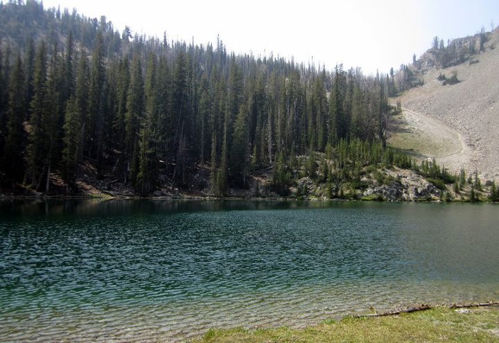
We didn't waste any time starting out on our first hike to Titus Lake.  Our first group photo was taken at the trailhead as we began the easy 3.4 miles to the lake.  The hike was, of course,....awesome.
We enjoyed viewpoints of the Boulder Mountains. 
We worried about the air quality due to the Idaho wildfires. 
However we soon realized the air quality would not be bad at all.
Beautiful Titus Lake 
Notice the tree in the water?
 
We hiked to the edge of the lake to capture a photo of this Fireweed flower.
These gorgeous flowers were growing out over the water and were quite pretty. 
We could see them from the other side of the lake and knew we had to get closer.
 
Hiking and smiling go hand in hand with good friends.
One group photo at the Lake and then it was back to the condo.
Hiking to Titus Lake started off our adventure perfectly.
The second day we hiked to Pioneer Cabin. 
Some of us had experienced this hike before and were excited to experience it again. 
The Pioneer Cabin hike was our longest at about 9 miles. 

Our destination was this little cabin at an elevation of 9,500 ft.
It is our favorite cabin in Sun Valley and worth every step it takes to get there. 
No one lives here and everyone is welcome.
The words on the cabin roof read,
"The higher you get the higher you get."
We most certainly agreed.
The cabin walls are covered with quotes, sayings, and signatures from previous visitors.
We found the names of our favorite visitors who had been there before and whom we just happened to know.
One can find all kinds of interesting items left on the shelves.
Adding to the scenery of the cabin are the magnificent mountains.  Words can't describe the view as we reached the summit and these mountains were there to greet us.   
A guitar left at the cabin was soon put to good use thanks to Nancy.
It's a good thing we can laugh at ourselves and at our singing. 
Carol King would be proud!
 
A great place to rest, enjoy lunch, and take in the views.
Sharon tried a new feature on her camera taking black and white photos.
Soon it was time to leave our favorite place in the Pioneer Mountains.
We were grateful for having been there and hope to return again one day.
Hiking was done for the day and we deserved ice cream at Konditorei.
It was yummy good and we were not disappointed.
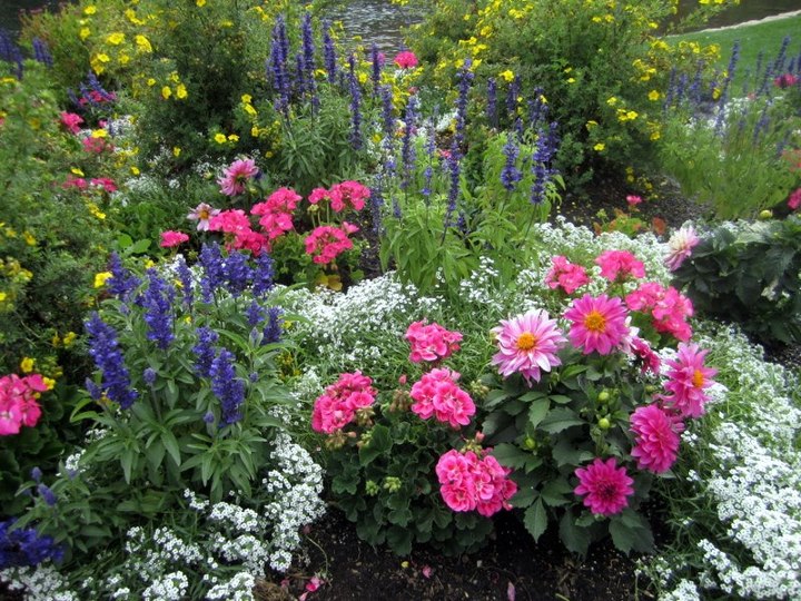
We are a group of women who love wildflowers and enjoy learning their names.  
So the beautiful flowers, wild or not, surrounding us there were not lost on us. 
We took time to enjoy the beautiful landscaping at the Sun Valley Lodge. 
We wondered if their landscaper hired out and would come to our homes.
Probably not. 
We saw many unique and beautiful plants and enjoyed our time spent touring the grounds.
The next day our last hike began with crossing this new bridge.  
This would also be our last group photo in Sun Valley.
 
Our destination was to Norton Lake.
It was beautifully green and the area was very peaceful.
Notice the trail up the mountain on the other side of the lake?
This is where our hiking group parted ways.  The trail completes a loop to two other lakes.
Three of us chose a shorter hike to this upper Norton Lake.
It was a beautiful lake but the wind was blowing and it got cold fast. 
Nancy, Sharon, and Lisa (not pictured) chose the loop to the other lakes.
Nancy and Sharon at Smoky Lake. 
Hiking the loop was on Nancy's bucket list and she was so happy to have completed the hike. 
Descending the boulder field from the Lakes.
 
Smoky Lake 2nd view 
Hiking in Sun Valley meant enjoying friendships... 
Performing handstands just because she can... 
Leaving happy signs along the trail... 
Leaving signs for others to let them know we were there... 
Building cairns... 
Wearing coordinated colors (but not on purpose)...
Love, love, loving the scenery... 
Meeting fellow hikers and their pets along the way... 
 Laughing and performing...
Always finding time to stop and chat... 
Crossing streams... 
Taking pictures and more pictures...
and feeling grateful indeed for hikers who make excellent tour guides.
 And
even better,
dear friends.
{Thank you Lisa and Nancy for a wonderful time!}